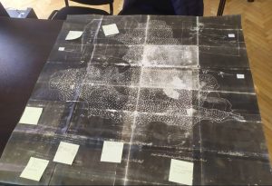
The Prilep archive found a rare and interesting map on which, it is believed, for the first time in the public was discovered a drawing of the famous Roman economic and trade road “Via Egnatia” that passes through Macedonia.
According to the director of the Prilep archive Elena Chagoroska, this is a very important historical map that has landmarks from very important historical places and landmarks. The map is an Ottoman document, dating from 1883. The then Husref beg-pasha, leaving the Prilep region, gave the property to the local population with fields, mills and so on. He wanted to show the value of the property, but also that Prilep is located at important crossroads.
”According to the information, “Via Egnatia” is first shown on a map. Otherwise, the road was built in 146 AD. It was built 44 years ago, according to archeological excavations. The local population participated in the construction. The purpose of the road was to connect East with West, i.e. the Adriatic to Thessaloniki and then to Byzantium, Constantinople, today’s Istanbul,” stressed Chagoroska.